| at: |
Tombigbee National Forest - South |
Data from USFS GIS
 show on map
 animate
Trail users:


Elevation Profile
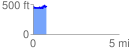
 0.783740 mi
 158.78 ft
 161.48 ft
 -2.70 ft
 3.90 %
GPX Downloads: Track Route
![]()
| at: |
Tombigbee National Forest - South |
show on map
animate
0.783740 mi
158.78 ft
161.48 ft
-2.70 ft
3.90 %