| at: |
Tombigbee National Forest - South |
Data from USFS GIS
 show on map
 animate
Trail users:


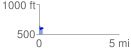
Elevation Profile
 0.212994 mi
 31.00 ft
 76.65 ft
 -45.65 ft
 6.82 %
GPX Downloads: Track Route
![]()
| at: |
Tombigbee National Forest - South |
show on map
animate
0.212994 mi
31.00 ft
76.65 ft
-45.65 ft
6.82 %