| at: |
Tombigbee National Forest - South |
Data from USFS GIS
 show on map
 animate
Trail users:


Elevation Profile
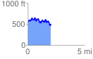
 2.049558 mi
 470.78 ft
 551.48 ft
 -80.71 ft
 5.10 %
GPX Downloads: Track Route
![]()
| at: |
Tombigbee National Forest - South |
show on map
animate
2.049558 mi
470.78 ft
551.48 ft
-80.71 ft
5.10 %