| at: |
Tombigbee National Forest - South |
Data from USFS GIS
 show on map
 animate
Trail users:


Elevation Profile
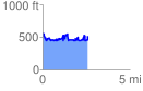
 2.605479 mi
 827.41 ft
 827.41 ft
 0.00 ft
 6.01 %
GPX Downloads: Track Route
![]()
| at: |
Tombigbee National Forest - South |
show on map
animate
2.605479 mi
827.41 ft
827.41 ft
0.00 ft
6.01 %