| at: |
Tombigbee National Forest - South |
Data from USFS GIS
 show on map
 animate
Trail users:


Elevation Profile
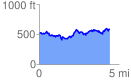
 4.408365 mi
 1095.98 ft
 1025.29 ft
 70.69 ft
 4.71 %
GPX Downloads: Track Route
![]()
| at: |
Tombigbee National Forest - South |
show on map
animate
4.408365 mi
1095.98 ft
1025.29 ft
70.69 ft
4.71 %