| at: |
Tombigbee National Forest - North |
Data from USFS GIS
 show on map
 animate
Trail users:


Elevation Profile
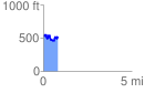
 0.820817 mi
 189.80 ft
 226.62 ft
 -36.82 ft
 5.23 %
GPX Downloads: Track Route
![]()
| at: |
Tombigbee National Forest - North |
show on map
animate
0.820817 mi
189.80 ft
226.62 ft
-36.82 ft
5.23 %