| at: |
Tombigbee National Forest - North |
Data from USFS GIS
 show on map
 animate
Trail users:


Elevation Profile
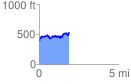
 1.908327 mi
 414.13 ft
 256.93 ft
 157.20 ft
 4.11 %
GPX Downloads: Track Route
![]()
| at: |
Tombigbee National Forest - North |
show on map
animate
1.908327 mi
414.13 ft
256.93 ft
157.20 ft
4.11 %