| at: |
Tombigbee National Forest - North |
Data from USFS GIS
 show on map
 animate
Trail users:


Elevation Profile
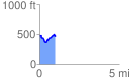
 1.039225 mi
 159.82 ft
 168.35 ft
 -8.53 ft
 3.07 %
GPX Downloads: Track Route
![]()
| at: |
Tombigbee National Forest - North |
show on map
animate
1.039225 mi
159.82 ft
168.35 ft
-8.53 ft
3.07 %