| at: |
Tombigbee National Forest - North |
Data from USFS GIS
 show on map
 animate
Trail users:


Elevation Profile
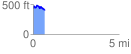
 0.668671 mi
 110.37 ft
 144.26 ft
 -33.89 ft
 4.09 %
GPX Downloads: Track Route
![]()
| at: |
Tombigbee National Forest - North |
show on map
animate
0.668671 mi
110.37 ft
144.26 ft
-33.89 ft
4.09 %