| at: |
Tombigbee National Forest - North |
Data from USFS GIS
 show on map
 animate
Trail users:


Elevation Profile
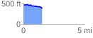
 1.529567 mi
 94.07 ft
 171.55 ft
 -77.48 ft
 2.12 %
GPX Downloads: Track Route
![]()
| at: |
Tombigbee National Forest - North |
show on map
animate
1.529567 mi
94.07 ft
171.55 ft
-77.48 ft
2.12 %