| at: |
Tombigbee National Forest - North |
Data from USFS GIS
 show on map
 animate
Trail users:


Elevation Profile
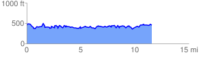
 11.706496 mi
 3113.97 ft
 3116.28 ft
 -2.30 ft
 5.04 %
GPX Downloads: Track Route
![]()
| at: |
Tombigbee National Forest - North |
show on map
animate
11.706496 mi
3113.97 ft
3116.28 ft
-2.30 ft
5.04 %