| at: |
Tombigbee National Forest - North |
Data from USFS GIS
 show on map
 animate
Trail users:


Elevation Profile
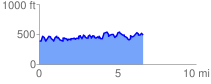
 6.713127 mi
 2050.54 ft
 1975.29 ft
 75.25 ft
 5.79 %
GPX Downloads: Track Route
![]()
| at: |
Tombigbee National Forest - North |
show on map
animate
6.713127 mi
2050.54 ft
1975.29 ft
75.25 ft
5.79 %