| at: |
Tombigbee National Forest - North |
Data from USFS GIS
 show on map
 animate
Trail users:


Elevation Profile
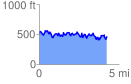
 4.283017 mi
 1419.30 ft
 1459.91 ft
 -40.61 ft
 6.46 %
GPX Downloads: Track Route
![]()
| at: |
Tombigbee National Forest - North |
show on map
animate
4.283017 mi
1419.30 ft
1459.91 ft
-40.61 ft
6.46 %