| at: |
Tombigbee National Forest - North |
Data from USFS GIS
 show on map
 animate
Trail users:


Elevation Profile
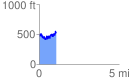
 1.087577 mi
 414.74 ft
 408.14 ft
 6.60 ft
 7.22 %
GPX Downloads: Track Route
![]()
| at: |
Tombigbee National Forest - North |
show on map
animate
1.087577 mi
414.74 ft
408.14 ft
6.60 ft
7.22 %