| at: |
Tombigbee National Forest - North |
Data from USFS GIS
 show on map
 animate
Trail users:


Elevation Profile
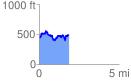
 1.873823 mi
 615.00 ft
 615.97 ft
 -0.97 ft
 6.23 %
GPX Downloads: Track Route
![]()
| at: |
Tombigbee National Forest - North |
show on map
animate
1.873823 mi
615.00 ft
615.97 ft
-0.97 ft
6.23 %