| at: |
Tombigbee National Forest - North |
Data from USFS GIS
 show on map
 animate
Trail users:


Elevation Profile
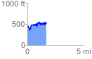
 1.704380 mi
 529.82 ft
 464.16 ft
 65.66 ft
 5.89 %
GPX Downloads: Track Route
![]()
| at: |
Tombigbee National Forest - North |
show on map
animate
1.704380 mi
529.82 ft
464.16 ft
65.66 ft
5.89 %