| at: |
Holly Springs National Forest - South |
Data from USFS GIS
 show on map
 animate
Trail users:


Elevation Profile
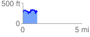
 1.244842 mi
 301.01 ft
 276.49 ft
 24.52 ft
 4.58 %
GPX Downloads: Track Route
![]()
| at: |
Holly Springs National Forest - South |
show on map
animate
1.244842 mi
301.01 ft
276.49 ft
24.52 ft
4.58 %