| at: |
Holly Springs National Forest - South |
Data from USFS GIS
 show on map
 animate
Trail users:


Elevation Profile
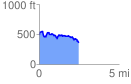
 2.489324 mi
 333.82 ft
 497.92 ft
 -164.10 ft
 3.79 %
GPX Downloads: Track Route
![]()
| at: |
Holly Springs National Forest - South |
show on map
animate
2.489324 mi
333.82 ft
497.92 ft
-164.10 ft
3.79 %