|
| at: |
Holly Springs National Forest - North |
Data from USFS GIS
 show on map
 animate
Trail users:


Elevation Profile
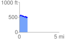
 1.016405 mi
 124.59 ft
 169.02 ft
 -44.43 ft
 3.15 %
GPX Downloads: Track Route
![]()
|
| at: |
Holly Springs National Forest - North |
show on map
animate
1.016405 mi
124.59 ft
169.02 ft
-44.43 ft
3.15 %