|
| at: |
Holly Springs National Forest - North |
Data from USFS GIS
 show on map
 animate
Trail users:


Elevation Profile
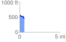
 0.562253 mi
 25.89 ft
 144.33 ft
 -118.44 ft
 4.86 %
GPX Downloads: Track Route
![]()
|
| at: |
Holly Springs National Forest - North |
show on map
animate
0.562253 mi
25.89 ft
144.33 ft
-118.44 ft
4.86 %