|
| at: |
Holly Springs National Forest - North |
Data from USFS GIS
 show on map
 animate
Trail users:


Elevation Profile
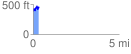
 0.345566 mi
 138.89 ft
 103.73 ft
 35.16 ft
 7.61 %
GPX Downloads: Track Route
![]()
|
| at: |
Holly Springs National Forest - North |
show on map
animate
0.345566 mi
138.89 ft
103.73 ft
35.16 ft
7.61 %