|
| at: |
Holly Springs National Forest - North |
Data from USFS GIS
 show on map
 animate
Trail users:


Elevation Profile
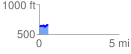
 0.588487 mi
 72.86 ft
 74.23 ft
 -1.37 ft
 2.39 %
GPX Downloads: Track Route
![]()
|
| at: |
Holly Springs National Forest - North |
show on map
animate
0.588487 mi
72.86 ft
74.23 ft
-1.37 ft
2.39 %