|
| at: |
Holly Springs National Forest - North |
Data from USFS GIS
 show on map
 animate
Trail users:


Elevation Profile
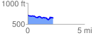
 2.259575 mi
 194.75 ft
 273.03 ft
 -78.28 ft
 2.29 %
GPX Downloads: Track Route
![]()
|
| at: |
Holly Springs National Forest - North |
show on map
animate
2.259575 mi
194.75 ft
273.03 ft
-78.28 ft
2.29 %