| at: |
Holly Springs National Forest - North |
Data from USFS GIS
 show on map
 animate
Trail users:


Elevation Profile
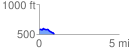
 0.941077 mi
 46.23 ft
 120.47 ft
 -74.24 ft
 2.42 %
GPX Downloads: Track Route
![]()
| at: |
Holly Springs National Forest - North |
show on map
animate
0.941077 mi
46.23 ft
120.47 ft
-74.24 ft
2.42 %