|
| at: |
Holly Springs National Forest - North |
Data from USFS GIS
 show on map
 animate
Trail users:


Elevation Profile
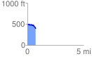
 0.747063 mi
 63.73 ft
 152.26 ft
 -88.53 ft
 3.86 %
GPX Downloads: Track Route
![]()
|
| at: |
Holly Springs National Forest - North |
show on map
animate
0.747063 mi
63.73 ft
152.26 ft
-88.53 ft
3.86 %