| at: |
Holly Springs National Forest - North |
Data from USFS GIS
 show on map
 animate
Trail users:


Elevation Profile
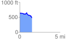
 1.507182 mi
 99.42 ft
 263.95 ft
 -164.53 ft
 3.32 %
GPX Downloads: Track Route
![]()
| at: |
Holly Springs National Forest - North |
show on map
animate
1.507182 mi
99.42 ft
263.95 ft
-164.53 ft
3.32 %