| at: |
Holly Springs National Forest - North |
Data from USFS GIS
 show on map
 animate
Trail users:


Elevation Profile
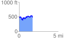
 1.712047 mi
 382.10 ft
 366.26 ft
 15.83 ft
 4.23 %
GPX Downloads: Track Route
![]()
| at: |
Holly Springs National Forest - North |
show on map
animate
1.712047 mi
382.10 ft
366.26 ft
15.83 ft
4.23 %