|
| at: |
Holly Springs National Forest - North |
Data from USFS GIS
 show on map
 animate
Trail users:


Elevation Profile
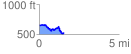
 1.542506 mi
 179.97 ft
 281.49 ft
 -101.51 ft
 3.46 %
GPX Downloads: Track Route
![]()
|
| at: |
Holly Springs National Forest - North |
show on map
animate
1.542506 mi
179.97 ft
281.49 ft
-101.51 ft
3.46 %