| at: |
Holly Springs National Forest - North |
Data from USFS GIS
 show on map
 animate
Trail users:


Elevation Profile
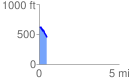
 0.479938 mi
 46.20 ft
 178.11 ft
 -131.91 ft
 7.03 %
GPX Downloads: Track Route
![]()
| at: |
Holly Springs National Forest - North |
show on map
animate
0.479938 mi
46.20 ft
178.11 ft
-131.91 ft
7.03 %