| at: |
Holly Springs National Forest - North |
Data from USFS GIS
 show on map
 animate
Trail users:


Elevation Profile
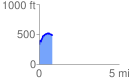
 0.819424 mi
 227.85 ft
 81.84 ft
 146.01 ft
 5.27 %
GPX Downloads: Track Route
![]()
| at: |
Holly Springs National Forest - North |
show on map
animate
0.819424 mi
227.85 ft
81.84 ft
146.01 ft
5.27 %