|
| at: |
Holly Springs National Forest - North |
Data from USFS GIS
 show on map
 animate
Trail users:


Elevation Profile
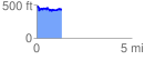
 1.307590 mi
 182.43 ft
 234.35 ft
 -51.93 ft
 3.39 %
GPX Downloads: Track Route
![]()
|
| at: |
Holly Springs National Forest - North |
show on map
animate
1.307590 mi
182.43 ft
234.35 ft
-51.93 ft
3.39 %