| at: |
Holly Springs National Forest - North |
Data from USFS GIS
 show on map
 animate
Trail users:


Elevation Profile
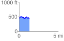
 1.329919 mi
 177.35 ft
 179.17 ft
 -1.82 ft
 2.55 %
GPX Downloads: Track Route
![]()
| at: |
Holly Springs National Forest - North |
show on map
animate
1.329919 mi
177.35 ft
179.17 ft
-1.82 ft
2.55 %