|
| at: |
Holly Springs National Forest - North |
Data from USFS GIS
 show on map
 animate
Trail users:


Elevation Profile
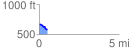
 0.525113 mi
 16.57 ft
 96.39 ft
 -79.83 ft
 3.48 %
GPX Downloads: Track Route
![]()
|
| at: |
Holly Springs National Forest - North |
show on map
animate
0.525113 mi
16.57 ft
96.39 ft
-79.83 ft
3.48 %