| at: |
Holly Springs National Forest - North |
Data from USFS GIS
 show on map
 animate
Trail users:


Elevation Profile
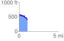
 1.074088 mi
 132.28 ft
 308.89 ft
 -176.61 ft
 5.45 %
GPX Downloads: Track Route
![]()
| at: |
Holly Springs National Forest - North |
show on map
animate
1.074088 mi
132.28 ft
308.89 ft
-176.61 ft
5.45 %