|
| at: |
Holly Springs National Forest - North |
Data from USFS GIS
 show on map
 animate
Trail users:


Elevation Profile
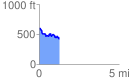
 1.292799 mi
 136.25 ft
 296.45 ft
 -160.20 ft
 4.34 %
GPX Downloads: Track Route
![]()
|
| at: |
Holly Springs National Forest - North |
show on map
animate
1.292799 mi
136.25 ft
296.45 ft
-160.20 ft
4.34 %