|
| at: |
Holly Springs National Forest - North |
Data from USFS GIS
 show on map
 animate
Trail users:


Elevation Profile
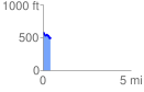
 0.443952 mi
 64.85 ft
 116.88 ft
 -52.03 ft
 4.99 %
GPX Downloads: Track Route
![]()
|
| at: |
Holly Springs National Forest - North |
show on map
animate
0.443952 mi
64.85 ft
116.88 ft
-52.03 ft
4.99 %