|
| at: |
Holly Springs National Forest - North |
Data from USFS GIS
 show on map
 animate
Trail users:


Elevation Profile
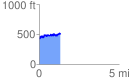
 1.312745 mi
 245.29 ft
 167.87 ft
 77.42 ft
 3.54 %
GPX Downloads: Track Route
![]()
|
| at: |
Holly Springs National Forest - North |
show on map
animate
1.312745 mi
245.29 ft
167.87 ft
77.42 ft
3.54 %