| at: |
Holly Springs National Forest - North |
Data from USFS GIS
 show on map
 animate
Trail users:


Elevation Profile
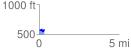
 0.329317 mi
 57.42 ft
 52.82 ft
 4.59 ft
 3.30 %
GPX Downloads: Track Route
![]()
| at: |
Holly Springs National Forest - North |
show on map
animate
0.329317 mi
57.42 ft
52.82 ft
4.59 ft
3.30 %