| at: |
Holly Springs National Forest - North |
Data from USFS GIS
 show on map
 animate
Trail users:


Elevation Profile
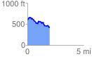
 1.972523 mi
 316.23 ft
 452.83 ft
 -136.60 ft
 4.35 %
GPX Downloads: Track Route
![]()
| at: |
Holly Springs National Forest - North |
show on map
animate
1.972523 mi
316.23 ft
452.83 ft
-136.60 ft
4.35 %