|
| at: |
Holly Springs National Forest - North |
Data from USFS GIS
 show on map
 animate
Trail users:


Elevation Profile
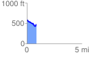
 0.871691 mi
 60.06 ft
 180.32 ft
 -120.25 ft
 3.92 %
GPX Downloads: Track Route
![]()
|
| at: |
Holly Springs National Forest - North |
show on map
animate
0.871691 mi
60.06 ft
180.32 ft
-120.25 ft
3.92 %