|
| at: |
Holly Springs National Forest - North |
Data from USFS GIS
 show on map
 animate
Trail users:


Elevation Profile
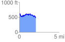
 2.075746 mi
 326.09 ft
 475.01 ft
 -148.91 ft
 4.33 %
GPX Downloads: Track Route
![]()
|
| at: |
Holly Springs National Forest - North |
show on map
animate
2.075746 mi
326.09 ft
475.01 ft
-148.91 ft
4.33 %