|
| at: |
Holly Springs National Forest - North |
Data from USFS GIS
 show on map
 animate
Trail users:


Elevation Profile
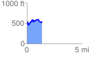
 1.376952 mi
 322.98 ft
 270.26 ft
 52.72 ft
 4.44 %
GPX Downloads: Track Route
![]()
|
| at: |
Holly Springs National Forest - North |
show on map
animate
1.376952 mi
322.98 ft
270.26 ft
52.72 ft
4.44 %