| at: |
Holly Springs National Forest - North |
Data from USFS GIS
 show on map
 animate
Trail users:


Elevation Profile
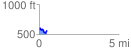
 0.497786 mi
 50.21 ft
 103.94 ft
 -53.72 ft
 3.95 %
GPX Downloads: Track Route
![]()
| at: |
Holly Springs National Forest - North |
show on map
animate
0.497786 mi
50.21 ft
103.94 ft
-53.72 ft
3.95 %