|
| at: |
Holly Springs National Forest - North |
Data from USFS GIS
 show on map
 animate
Trail users:


Elevation Profile
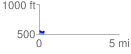
 0.321910 mi
 40.64 ft
 36.95 ft
 3.69 ft
 2.39 %
GPX Downloads: Track Route
![]()
|
| at: |
Holly Springs National Forest - North |
show on map
animate
0.321910 mi
40.64 ft
36.95 ft
3.69 ft
2.39 %