| at: |
Holly Springs National Forest - North |
Data from USFS GIS
 show on map
 animate
Trail users:


Elevation Profile
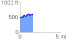
 1.579255 mi
 321.02 ft
 250.29 ft
 70.73 ft
 3.85 %
GPX Downloads: Track Route
![]()
| at: |
Holly Springs National Forest - North |
show on map
animate
1.579255 mi
321.02 ft
250.29 ft
70.73 ft
3.85 %