|
| at: |
Holly Springs National Forest - North |
Data from USFS GIS
 show on map
 animate
Trail users:


Elevation Profile
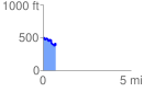
 0.730178 mi
 88.54 ft
 217.84 ft
 -129.30 ft
 5.65 %
GPX Downloads: Track Route
![]()
|
| at: |
Holly Springs National Forest - North |
show on map
animate
0.730178 mi
88.54 ft
217.84 ft
-129.30 ft
5.65 %