| at: |
Holly Springs National Forest - North |
Data from USFS GIS
 show on map
 animate
Trail users:


Elevation Profile
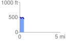
 0.541800 mi
 40.17 ft
 85.47 ft
 -45.30 ft
 2.99 %
GPX Downloads: Track Route
![]()
| at: |
Holly Springs National Forest - North |
show on map
animate
0.541800 mi
40.17 ft
85.47 ft
-45.30 ft
2.99 %