|
| at: |
Holly Springs National Forest - North |
Data from USFS GIS
 show on map
 animate
Trail users:


Elevation Profile
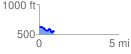
 0.913391 mi
 71.10 ft
 179.32 ft
 -108.23 ft
 3.72 %
GPX Downloads: Track Route
![]()
|
| at: |
Holly Springs National Forest - North |
show on map
animate
0.913391 mi
71.10 ft
179.32 ft
-108.23 ft
3.72 %