|
| at: |
Holly Springs National Forest - North |
Data from USFS GIS
 show on map
 animate
Trail users:


Elevation Profile
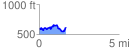
 1.674572 mi
 286.54 ft
 267.91 ft
 18.63 ft
 3.24 %
GPX Downloads: Track Route
![]()
|
| at: |
Holly Springs National Forest - North |
show on map
animate
1.674572 mi
286.54 ft
267.91 ft
18.63 ft
3.24 %