|
| at: |
Holly Springs National Forest - North |
Data from USFS GIS
 show on map
 animate
Trail users:


Elevation Profile
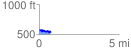
 0.719899 mi
 93.92 ft
 145.90 ft
 -51.98 ft
 3.84 %
GPX Downloads: Track Route
![]()
|
| at: |
Holly Springs National Forest - North |
show on map
animate
0.719899 mi
93.92 ft
145.90 ft
-51.98 ft
3.84 %